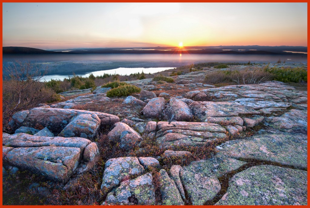
“Between every two pine trees there is a door leading to a new way of life….climb the mountains and get their good tidings. Nature’s peace will flow into you as sunshine into trees” John Muir

I had been to Acadia National Park a number of times over the years, but never in autumn when New England color is ablaze. And I also knew that the visibility of the Milky Way’s galactic core would begin to wane in late October. So off we went on our five hour drive up the Maine coast to Bar Harbor, Maine.

Confused in Maine

This is why they invented GPS. I thought I was on Rt. 1 South, but apparently I was in a multi-directional vortex.

Cadillac Mountain Sunrise

Cadillac Mountain is one of the iconic places in the park and very crowded at sunrise and sunset as everyone wants to experience the beauty and mystery of night turning into day or day transforming into night. Cadillac Mountain is the highest point (1,530 ft.) on Atlantic coast from Maine to Brazil and is largely composed of stunning pink hued granite. The area is famous for its’ high quality granite and it was used in many of the country’s institutional buildings, the U.S. Treasury building in Washington D.C. being a prime example.

Surveying the Scene

Even the Gulls enjoy the view from the top of the park.

Boulder’s Beach

This is Boulder Beach which, as you can see, is an apropos name. This is early in the morning just as first light is coming over the horizon. This light is very blue and it added an eerie feeling to the image. Moving across these rocks is hazardous as they can be slippery and they often move as you gingerly step on them.

Otter Point

This section of the park is popular with photographers because the sunrise is due east of here and the morning sun lights up the red granite that lines this coast. This color only lasts a few minutes and if you miss it, it’ll be back in 24 hours.

Milky Way

Photographing the Milky Way was one of my objectives in traveling to the park. The eastern coast of Northern Maine has the darkest skies in New England and is the best place in New England to do astrophotography. You might notice that the most dense and colorful section of the MW is right at the horizon. In another month, this section of the MW would no longer be visible in the night sky until Spring.

White Birches in the Meadow

The park has a section of low meadow land which is populated by these white birches. It’s challenging to find a good composition because of the haphazard tree placements.

Carriage Road

The Carriage Roads and stone bridges in Acadia National Park were financed and directed by philanthropist John D. Rockefeller, Jr., between 1913 and 1940, for hikers, bikers, horseback riders and carriages. The network includes 57 miles of woodland roads free of motor vehicles, of which 45 miles are within Acadia National Park.

These are some of the most spectacular hiking trails you will ever encounter, particularly in autumn.

Bass Harbor Head Lighthouse

The Bass Harbor Lighthouse is among the most photographed and visited in the U.S. It’s particularly popular at sunset when the sun lights up this section of the park’s coastline. On any given summer or fall day, there will be hundreds of folks climbing all over these rocks as sunset approches. I shot this image on a previous trip to the park. On the day we visited the lighthouse there was a torrential rain and windstorm, but amazingly, there were still many people walking down the short trail to this area.

Hunter’s Head

I got up each morning in the dark and went to Hunter’s Head to try and get a great sunrise view. The good sunset composition is in the opposite direction and I set my camera and tripod up to capture a golden sunrise over the little cove in that direction. But alas, each morning the hoped for sunrise glory never materialized. On the last day I turned around to go back to my car and noticed that the risen sun was lighting up the area on the other side of Hunter’s Head. This golden rust color only lasted 2 minutes and I was forunate to get this wonderful image.

Thank you for reading my latest blog entry. If you thought it was worthy of your time and you hadn’t already done so, please take the opportunity to subscribe by clicking the “Follow” button on the right side of this page. You will receive an email asking you to confirm your subscription. Also, you can share this blog entry on your Facebook page by clicking the share button below or you can email it to folks by clicking on the “Email” button.

Lastly, if you are inclined, I have many of these images and more on my home web page:

http://www.frankbinderphotography.com

Frank Binder

65,000 moose roam the Yukon, an area roughly 2 1/2 times the size of New England. This is about twice the human population of the territory. With the capital of Whitehorse having a population of 23,000, the arithmetic says that the human population of the territory outside of Whitehorse is about 9,000….wow, talk about scarcely populated areas!!

The territory is home to fourteen First Nation peoples each with its own unique traditions and cultural heritage. The Tombstone territorial Park is an important heritage of the Tr’ondëk Hwëch’in people who have hunted and camped here for centuries and who agreed in 1999, in conjunction with the territorial government, to the formation of the park

Sunrise over Tombstone Mountain

Memorable for its black granite peaks, idyllic alpine lakes and subarctic tundra
landscapes, Tombstone Territorial Park is an icon among Yukon destinations.

Tombstone Reflections

These peaks always draw your attention as the light and weather conditions provide constantly changing dramatic views of this view. In the scene above, the lake surface became a mirror as the wind disappeared and allowed the capture of this pristine scene in the reflections of the Lake.

Sunset over Tombstone Mountain

This is the same view with a particularly colorful sunset decorating the valley.

Sunburst in the Valley

For years one of the cardinal rules of photography was always shoot with the sun at your back. With the advent of new cameras and the technologies embedded in their sensors, that rule has gone the way of the rotary dial phone. In the above image I shot directly into the sun and recorded the stunning back-lit colors of the low lying shrubs illuminated by the setting sun. The ragged cloud formations add to the scene.

The Aurora in the valley

By professional landscape photographer standards, this is a rather pedestrian image of the Northern Lights. But this was my first opportunity to see and photograph this amazing phenomenon and I couldn’t have been more excited about the opportunity. It meant rising in the middle of the night each night to see if the Aurora was visible. Most nights it wasn’t because of the cloud cover. This night was the only opportunity we had to capture a view of the Aurora. One of my colleagues had the inspirational idea to light up a tent to use as a foreground for the image.

Yellow and Gold
Yellow and Gold

This image has the rough hewn textures of the boulder on the bottom of the image and the peaks on the top sandwiched around the carpet of yellow and gold spread across the sub-artic tundra.

Drama over Tombstone

Of course this is the same view as above only with a different cloud formation. You will also notice I converted the upper 2/3 thirds of the scene into a black and white image while retaining the golden hue of the tundra which I think complements the stark drama of the image. In the photographic community writ large, some would view this as a complete violation of photographic integrity. Obviously, I’m not in that camp.

Morning Reflections
Morning Reflections

This would be a rather ordinary image but the lovely pink hue of the clouds and the reflections in the still water in the foreground turn it into something special.

Splendor over Tombstone

This image was taken only a few minutes after the image directly above.  In just those few minutes the cloud edges were lit up with these wonderful points of light giving the scene a completely different look.

I’ll close this post and conclude the three posts on my Yukon visit with a photo of yours truly and my three photographer buddies (courtesy of Jim Ruff) from whom I learned something every day.

Frank Binder, Doug Solis, Denis Dessolier, Jim Ruff

Thank you for reading my latest blog entry. If you thought it was worthy of your time and you hadn’t already done so, please take the opportunity to subscribe by clicking the “Follow” button on the right side of the page. You will receive an email asking you to confirm your subscription. Also, you can share this blog entry on your Facebook page by clicking the share button below or you can email it to folks by clicking on the “Email” button.

Frank

Shrewsbury, MA

Puffs of smoke and the screech of tires from touchdown dissipated into the darkness as my late night Jetblue flight taxied to the gate. “Welcome to Las Vegas. Your checked bags will be at carousel five” announced our flight attendant. After gathering my camera bag I shuffled off the plane with my fellow passengers and went to carousel five to get my luggage. It arrived quickly and I moved outside to get a taxi

The taxi line at McCarron Field is very organized. You get in the taxi line  which is monitored and managed by several efficient folks who move you to a location where a taxi and you arrive simultaneaously. The line took a few minutes to clear everyone and I took the opportunity to once again congratulate myself for getting a great room at Circus Circus for $27.

My fortiesh driver popped out of his taxi sporting a bright yellow mohawk bisecting his shaved skull and accessorizing tats over most of his body, including his skull. And of course he wore the appropriate Megadeath teeshirt with chains that could have been used as snow chains in Minneapolis in January. As we drove to Circus Circus, I initiated a little small talk and asked what brought him to Las Vegas. “About ten years ago I lived in Indiana when my ex-wife and her boyfriend kidnapped my daughter and moved her to Michigan”, he said. He proceeded to narrate a personal saga of retribution that included breaking and entering, car chases, weapons, heavy police presence across the midwest, incarceration and finally refuge in Las Vegas. Jeez! I’ve been picked up by Travis Bickel.

We stopped at a traffic light and he rolled down his window next to a car of fully decked out young women and sought their friendship by asking several personal intimate questions. The girls rolled their eyes and windows and moved on down the road. He did this several more times at other traffic lights using pick up lines that, according to him, almost always land him a girlfriend or two for the evening. It didn’t appear to be working. My head was on a desperate swivel looking for Circus Circus.

_DSC5815
Valley of Fire State Park

Fifty miles northeast of Las Vegas, Valley of Fire State Park is Nevada’s oldest state park. After being in the park for a while, one gets the feeling that in some past time an ancient artistic God was challenged to decorate this land with the wildest possible array of sandstone sculptures and that he took his work seriously.

_DSC5800
Sandstone Bumps

The park derives its name from the red sandstone formations created during the dinosaur age by uplifting of the land and refined over millions of years by constant wind and water erosion. It’s formations are unlike many other southwest sandstone formations which have a weathered smooth appearance from all the years of wind and water. These formations have a jagged look as if they were sandstone lava that just popped out of the earth’s crust and recently cooled.

_DSC5787
On the Road

 Summer temperatures in the park can approach 120 degrees so the other three seasons are great times to visit the park.

Spheres
Spheres

This is an area called the Fire Wave. It’s one of the really cool locations in the park but confoundingly, it’s not on any of the park provided maps.

Atlatl Petroglyphs
Atlatl Petroglyphs

The Atlatl, the predecessor to the bow and arrow, was a notched stick used by ancient peoples to throw spears. You can see a depiction of it in the bottom center of this petroglyph image. It’s thought that this wall art was created about 3,000 years ago. Some of the images on the wall are obvious but others are still mysteries to the university experts. Sadly, the parts of this wall art that are reachable have now been protected with a hard plastic shell because some visitors to the park have seen fit to scratch graffiti among the figures.

Afternoon Light
Afternoon Light

This is the situation that photographers look for; shafts of light shooting across a grand landscape. In this case the main shaft of light illuminates formations in the center of the image, but there is also some light on the background formations in the upper third of the image.

Fire in the Sky
Fire in the Sky

I like the look of the fire raging in the clouds in this image. I wish I had found a better foreground that might have had a line of these bushes leading to the distant cloud fire.

Lines in the Sand
Lines in the Sand

This image and the next image are from a different state park, Coral Dunes State Park in Utah. They were both taken late in the afternoon with dramatic sidelighting.

_DSC5399
Coral Dunes

There are special challenges involved in photographing sand dunes. Protecting equipment from the blowing sand is very important. On this day the wind was blowing a modest 10-15 mph but it carried this fine dust which will get into every part of your camera if it’s not protected. I used a plastic cover which was not 100% effective.

Thank you for reading my latest blog entry. If you thought it was worthy of your time and you hadn’t already done so, please take the opportunity to subscribe by clicking the “Follow” button on the right side of the page. You will receive an email asking you to confirm your subscription. Also, you can share this blog entry on your Facebook page by clicking the share button below or you can email it to folks by clicking on the “Email” button.

Shrewsbury, MA

I was seated at a booth in Escobar’s Mexican Restaurant in Kanab, Utah, when Camille approached me with her name tag and pad and pencil in hand. “What’ll you have?”, she asked.  She didn’t approach me with the ingenuous greeting of so many servers….”Hi, my name is Camille and I’ll be your server today”. Nope, Camille didn’t play that. I immediately knew this was my kind of place. But it was more than the lack of the faux friendly greeting. It was the fellow diners who were all local blue-collar folks, the decor which was decidedly not high fashion, the smell from the kitchen which screamed serious chile, and the unpretentious look and attitude of the restaurant and employees. If the place ever had pretense, it had taken the train to Santa Fe long ago. The weathered look, the scarred and well used wooden tables and chairs, and the slightly tacky wall art all communicated substance and authenticity. Yep, this was my kind of place. I ordered the special; Flautas.

Settled by ten Mormon families in 1870, Kanab is a small and amiable town of about 3,000 folks in southern Utah just a few miles north of the Arizona border. It’s surrounded by the red cliffs and canyons of Escalante National Monument and is a very popular setting for Hollywood movies. It gained traction as a movie location in the 1950s when many of the Hollywood westerns made in that era were filmed in and around Kanab. Since then over two hundred movies have been filmed in the area and the town has become known as “Little Hollywood”.The town’s main drag is populated with placards and photos commemorating many of the movies and movie stars who have appeared in the town.

But for tourists, photographers and adventurers, Kanab is the gateway to some of our country’s most exciting and spectacular locales. It sits centrally among what many would argue are our country’s most beautiful national protected lands; Zion, Bryce and Grand Canyon (north rim) National Parks, Paria Canyon-Vermillion Cliffs Wilderness Area, and Grand Staircase Escalante National Monument.

The Wave

Hidden in the Paria Canyon-Vermillion Wilderness area, about forty miles east of Kanab, you will find North Coyote Buttes. North Coyote Buttes is an amazing explosion of swirling eroding and sometimes grotesque looking Navajo Jurassic Sandstone with dinosaur tracks traversing many of the formations. Among all of the wonderful formations in the area, the unrivaled rock star of rock formations is an area of roughly 5,000 sq ft called “The Wave”. The story goes that Europeans discovered the wave 20-30 years ago and made it famous. Of course, they didn’t really discover it, but the formation gained enormous notoriety in Europe and landed on the bucket list of most Europeans who visited the American southwest. Eventually the formation became so popular that the Bureau of Land Management instituted a permit system in which only twenty people a day can visit the area. Ten are awarded using an on-line system months prior to the visit day and ten are awarded by lottery the day before the intended visit. In the Spring and Summer months, the BLM office in Kanab regularly gets over 100 people entering the lottery and most days half of all lottery hopefuls are from outside the U.S.

The Wave 2

Because of the positioning of the wave, it only gets full sunlight in the summer months. The opportune time to photograph it is either in full sunlight or on an overcast day, which doesn’t happen that often in a place that gets over 300 days of sunlight a year. So on a sunny November day a photographer needs to pick out smaller pieces of the formation that are either in full sun or full shade.

Muffin Tops

North Coyote Buttes contains an incredible diversity of colors and formations, but amazingly many visitors hike to the wave, check it off their photographic bucket list by taking a few photos and then turn around and hike out. Those folks are missing a lot. Look at the above photo; all of the muffin top formations lie in front of sweeping horizontal and diagonal lines some of which swirl around the cone-shaped formation in the center right portion of the image. It’s a great juxtaposition of lines and texture!

Top of the Hill

This is the same area as the above photo but with a vertical view. Most photographers don’t take enough vertical images.

Popovers

“The Wave” is just behind these round popover like formations.

Approaching the Throne

Clear blue skies are normally desirable, but not so much for photographers. We prefer some clouds..dramatic weather borne clouds if possible. On clear blue sky days, I prefer to find images without the sky. The other option is to use a polarizer filter and turn the sky a deep blue and use it to frame the main image.

The Hamburger

There’s an old adage that if a million monkeys typed for a million years that one of them would eventually correctly type the entire Gettysburg Address, complete with punctuation! There must be a geologic corollary which states that over the course of a million years with wind, water and climatic changes occurring regularly, somewhere on earth a perfect sandstone hamburger will form. How did McDonalds miss this?

Fatali’s Boneyard

This section of North Coyote Buttes is Fatali’s Boneyard named after photographer Michael Fatali who made some striking images of the area and popularized them through his gallery in Springdale, UT.

Accordion Lines

Thank you for reading my latest blog entry. If you thought it was worthy of your time and you hadn’t already done so, please take the opportunity to subscribe by clicking the “Follow” button on the right side of the page. You will receive an email asking you to confirm your subscription. Also, you can share this blog entry on your Facebook page by clicking the share button below or you can email it to folks by clicking on the “Email” button.

Shrewsbury, MA

%d bloggers like this: