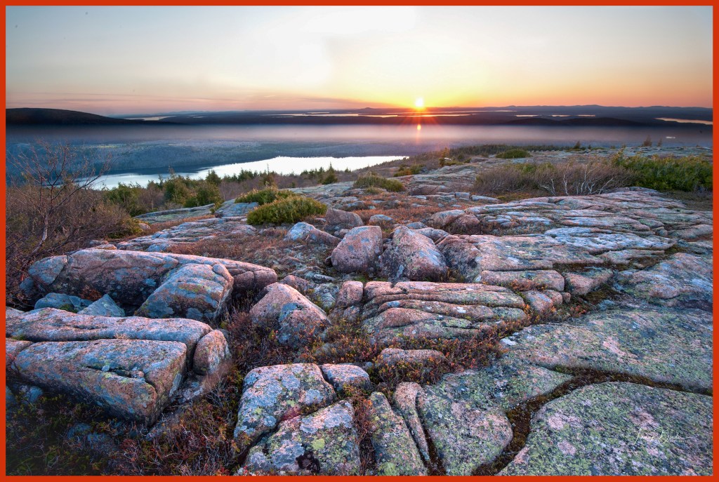
“Between every two pine trees there is a door leading to a new way of life….climb the mountains and get their good tidings. Nature’s peace will flow into you as sunshine into trees” John Muir

I had been to Acadia National Park a number of times over the years, but never in autumn when New England color is ablaze. And I also knew that the visibility of the Milky Way’s galactic core would begin to wane in late October. So off we went on our five hour drive up the Maine coast to Bar Harbor, Maine.

Confused in Maine

This is why they invented GPS. I thought I was on Rt. 1 South, but apparently I was in a multi-directional vortex.

Cadillac Mountain Sunrise

Cadillac Mountain is one of the iconic places in the park and very crowded at sunrise and sunset as everyone wants to experience the beauty and mystery of night turning into day or day transforming into night. Cadillac Mountain is the highest point (1,530 ft.) on Atlantic coast from Maine to Brazil and is largely composed of stunning pink hued granite. The area is famous for its’ high quality granite and it was used in many of the country’s institutional buildings, the U.S. Treasury building in Washington D.C. being a prime example.

Surveying the Scene

Even the Gulls enjoy the view from the top of the park.

Boulder’s Beach

This is Boulder Beach which, as you can see, is an apropos name. This is early in the morning just as first light is coming over the horizon. This light is very blue and it added an eerie feeling to the image. Moving across these rocks is hazardous as they can be slippery and they often move as you gingerly step on them.

Otter Point

This section of the park is popular with photographers because the sunrise is due east of here and the morning sun lights up the red granite that lines this coast. This color only lasts a few minutes and if you miss it, it’ll be back in 24 hours.

Milky Way

Photographing the Milky Way was one of my objectives in traveling to the park. The eastern coast of Northern Maine has the darkest skies in New England and is the best place in New England to do astrophotography. You might notice that the most dense and colorful section of the MW is right at the horizon. In another month, this section of the MW would no longer be visible in the night sky until Spring.

White Birches in the Meadow

The park has a section of low meadow land which is populated by these white birches. It’s challenging to find a good composition because of the haphazard tree placements.

Carriage Road

The Carriage Roads and stone bridges in Acadia National Park were financed and directed by philanthropist John D. Rockefeller, Jr., between 1913 and 1940, for hikers, bikers, horseback riders and carriages. The network includes 57 miles of woodland roads free of motor vehicles, of which 45 miles are within Acadia National Park.

These are some of the most spectacular hiking trails you will ever encounter, particularly in autumn.

Bass Harbor Head Lighthouse

The Bass Harbor Lighthouse is among the most photographed and visited in the U.S. It’s particularly popular at sunset when the sun lights up this section of the park’s coastline. On any given summer or fall day, there will be hundreds of folks climbing all over these rocks as sunset approches. I shot this image on a previous trip to the park. On the day we visited the lighthouse there was a torrential rain and windstorm, but amazingly, there were still many people walking down the short trail to this area.

Hunter’s Head

I got up each morning in the dark and went to Hunter’s Head to try and get a great sunrise view. The good sunset composition is in the opposite direction and I set my camera and tripod up to capture a golden sunrise over the little cove in that direction. But alas, each morning the hoped for sunrise glory never materialized. On the last day I turned around to go back to my car and noticed that the risen sun was lighting up the area on the other side of Hunter’s Head. This golden rust color only lasted 2 minutes and I was forunate to get this wonderful image.

Thank you for reading my latest blog entry. If you thought it was worthy of your time and you hadn’t already done so, please take the opportunity to subscribe by clicking the “Follow” button on the right side of this page. You will receive an email asking you to confirm your subscription. Also, you can share this blog entry on your Facebook page by clicking the share button below or you can email it to folks by clicking on the “Email” button.

Lastly, if you are inclined, I have many of these images and more on my home web page:

http://www.frankbinderphotography.com

Frank Binder

To quote Ken Burns…..National Parks are the country’s best idea. The breadth of the country’s national park experience varies from the flat swampy bird filled Everglades NP to the ice fields of Glacier NP to the spectacular cliffs and spires of Grand Canyon NP and everything in between.

If you’re into canyons and rock formations, southern Utah contains five national parks with some of the best hiking and photography anywhere on the planet.

Mesa Arch
Mesa Arch, Canyonlands National Park

Canyonlands NP contains one of the most famous arches in the country; Mesa Arch which has been photographed millions of times. The shot above is not particularly original but it’s on most landscape photographers bucket list since the light from the sunrise reflects off of the bottom surface of the arch and brilliantly lights up the underside of the arch. The brilliant red/orange glow on the underside of the arch lasts 15 minutes before it melts away for the rest of the day.

Obviously one needs to get here before sunrise to get in position to take the shot and capture the sun star in the image. I got there an hour before sunrise ( I needed a headlamp to walk the trail) and was greeted by 20 other tripod equipped photographers when I arrived. The arch is less than 20 ft. across and getting positioned in such a crowd takes some patience and a sharing attitude as you will undoubtedly be crossing tripod legs and bumping each other frequently.

_DSC3387
Delicate Arch

As the most popular arch in Arches NP, Delicate Arch draws tens of thousands of visitors each year….and rightly so! There were probably 50 people viewing and taking photos of the arch the afternoon I was there. As you can see in the image, the setting sun casts beautiful light on the arch in the last hour of the day and gives the arch the rich red glow that makes the image. Of course having the snow-capped La Sal Mountain range in the background helps.

Thor's Hammer
Thor’s Hammer

Among a host of natural formations, Thor’s hammer is likely the most iconic image of Bryce Canyon NP. Belying the name, Bryce Canyon is not really a canyon. It has no river running through it carving the formations over millions of years (like the Grand Canyon or Zion Canyon). The hoodoos in the park stand on cliff sides and have been formed over millions of years by water seeping into the rock with the resulting ice expansions causing disruptions in the rock.

_DSC3102
Bryce at night

The Milky Way was in the wrong place this night ( I guess it’s never really in the wrong place….it just wasn’t where I wanted it to be to place it in this image!). This tree shape is perfect for this shot…..it leans into the frame and has the right balance of branches.

Dead Horse Point State Park

The legend is that early cowboys would run wild mustangs into a natural narrow ledge on a cliff overlooking a 2,000 ft. drop and close a fence on the ledge when they gathered the horses. At one point, apparently, the horses were not released and subsequently died of thirst….hence the name.

Zion National Park
Zion National Park

Unlike Bryce Canyon or the Grand Canyon, visitors to Zion enter the park at the bottom of the famous canyon carved over the millennia by the Virgin River.  Many of the most famous hikes in the park rise dramatically as you wind your way up to the top of the 2,500 ft. cliffs. The Angels Landing trail leads an intrepid hiker to the small mesa (Angels Landing) which is only accessible by climbing across steep ledges with rock cliffs on one side and a 2,000 ft. fall off on the immediate other side. Helpfully, park rangers have installed chains on the cliff side to hang on to.

Afternoon Light
Afternoon Light

Sometimes serendipity happens and you have to be ready to see it and capture it. By itself this tree isn’t particularly scenic or dramatic, but the afternoon the sun lit up the tree and it was possible to isolate the tree away from the background and make a very nice image.


Broken Arch
Broken Arch

Broken Arch is in Arches NP and gets its name from the split in the top of the arch which looks like it’s about to break.

Spikes
Spikes

Another serendipitous moment…..seeing these and imagining the image is part of the photographers skill. This spiky tree in the shadows shows off well against the red Cliffs and blue sky in the background.

Turret Arch

Another of the iconic images in Arches NP. You have to be a little adventurous to get this image because the correct photographic spot is up on a small ledge with an access trail that requires quite a bit of agility to navigate. But of course….no problem for me!!

Thank you for reading my latest blog entry. If you thought it was worthy of your time and you hadn’t already done so, please take the opportunity to subscribe by clicking the “Follow” button in the middle of the right side of this page. You will receive an email asking you to confirm your subscription. Also, you can share this blog entry on your Facebook page by clicking the share button below or you can email it to folks by clicking on the “Email” button.

Frank

Shrewsbury, MA

During my recent January visit to Death Valley I observed to a local that very few visitors were in the park and that I found this surprising given the moderate winter temperatures (daytime in the 60’s and 70’s). I ventured that summer would be a terrible time to visit because of the well-known record high heat indexes. “Au Contraire” said the local….summer is the park’s high season and the valley is filled with foreign tourists that the park’s rangers recognize as “Heat Tourists”. These are people who want to experience some of the highest temperatures on earth for themselves, even though they can’t actually spend a great deal of time outside in the furnace-like conditions.

Death Valley Dunes
Death Valley Dunes

This was my first visit to Death Valley National Park and it kindled fond memories of watching “Death Valley Days” in black & white on our first family television in the 1950s. It was sponsored by Twenty Mule Team Borax which was a popular clothes detergent at the time (Can you imagine Millennials buying a cleaning product made of borax today?). Those “Mad Men” advertising folks were right on the money…….huge amounts of borax were mined in Death Valley in the early and mid twentieth century and in the early days, the borax was indeed carried out of the mines to processing centers in wagons pulled by teams of twenty mules.

20 Mule Team Placque

Furnace Creek is the locale where earth’s highest recorded temperature occurred in 1913….134 degrees. Average day time highs in the summer are 116 degrees.

Dunes
Dunes

I expected that most of the valley floor would be covered with sand dunes but the dunes cover only a small portion of the valley.


Salt Flats
Salt Flats

Much of the valley floor is composed of these salt flats which are formed when water from the surrounding mountains carry sediments down onto the valley floor where the water eventually evaporates and leaves the minerals (much of it salt) sitting on valley surface

Moon rising in Death Valley

In addition to Death Valley, Death Valley National Park encompasses a wonderful variety of different landscapes and environments including other smaller valleys and various mountain ranges. These Joshua trees are in the park but about 10 miles from Death Valley itself.

Layers
Layers

I shot this on one of the scenic mountain peaks surrounding Death Valley just as the sun was rising. If you look carefully, you can see the various layers of mountains and color.

Sunrise Across The Dunes

One of the enduring lessons in photography is during those magic moments when the light is special….look around! As I was taking the “Layers” photograph above, the dunes behind me were being lit up by the sunrise. This kind of scene lasts less than five minutes because the rising sun gradually fills in the shadows and the drama disappears. Lucky I turned around to see what was happening behind me!

Dunes at Sunset
Dunes at Sunset

To get a sense of scale…notice the figure walking on top of the dunes in the upper left portion of the image.
Thank you for reading my latest blog entry. If you thought it was worthy of your time and you hadn’t already done so, please take the opportunity to subscribe by clicking the “Follow” button on the right side of the page. You will receive an email asking you to confirm your subscription. Also, you can share this blog entry on your Facebook page by clicking the share button below or you can email it to folks by clicking on the “Email” button.

Frank

Shrewsbury, MA

Here’s a little quiz for you geography geeks….where is the highest and lowest point in the continental United States? Well amazingly, they’re within 100 miles of each other in eastern California. Mt. Whitney is the tallest mountain in the lower 48 states and of course, Death Valley is the lowest spot in the U.S.

In January, along with six other folks, I joined a photography workshop in California led by the superlative professional photographer Marc Adamus. In the course of a week we covered several thousand miles of California splendor as Marc continually put us in position to capture iconic images.

Mt. Whitney
Mt. Whitney


_DSC2413 - Version 2
The Alabama Hills

The Alabama Hills are a legendary set of rock formations in Lone Pine, California and were the location of virtually every western movie (and many TV shows) made in the 1950s and 1960s. A local road called “Movie Road” meanders though the hills and the sites of some of the most renown western movies. John Wayne, Robert Mitchum, Lorne Greene, Tom Mix, and Roy Rogers were regular visitors to Lone Pine (could this town have a better name?). Their photos and hundreds of others are hanging in many of the town’s restaurants.

_DSC1736
Eastern Sierras View with the Owens River

The Owens River flows through the Owens valley in eastern California and was the target of the fierce California water wars in the early 1900s. Facing an increasing population and decreasing water availability,  the city of Los Angeles bought up land in the Owens Valley and constructed an aqueduct to carry the water out of the Owens Valley into Los Angeles. By 1920 the city had completely drained Owens Lake and valley farmers were irate that their agriculture businesses were in danger of collapsing. This led to years of years of resistance and accompanying violence (farmers blew up the aqueduct repeatedly). Aspects of the conflict were the basis of the Jack Nicholson film Chinatown

Eastern Sierras as seen in Bishop, CA


Bishop, CA ranchland

The area around Bishop California is prime photographic territory. Galen Rowell, one of photography’s luminary figures was based in Bishop and although he passed away years ago in a plane crash, his Mountain Light Gallery in Bishop is a must see for everybody. His work is an inspiration to all aspiring landscape photographers.

Follow the Curve
Follow the Curve

This day there were intermittent storms and cloudy conditions that obscured the mountains but occasionally there would be a luminous shaft of light that would strike the landscape. My goal was to find something photogenic and wait for that shaft of light to make some magic.
I found this curved fence line leading to this lone tree with blue toned clouds obscuring the mountains in the background.


Morning Light
Morning Light


Mono Lake
Mono Lake

These stalagmite structures called “Tufas” sprout up in heavily carbonated Mono Lake as a result of underground springs rich in calcium rising in the lake and interacting with the carbonated water with the resulting calcium carbonate material incrementally forming these spires (Wow!  heavy science info!). The water level has receded significantly in the past 50 years leaving many of the largest Tufas on the shoreline where photographers photograph them incessantly.

_DSC2267_2
Sunset over Mammoth Lakes

Mammoth Lakes resort is on the northern portion of the Sierra Range and like much of California in the past few years is experiencing severe drought conditions with the natural snow pack on the mountain being much smaller than normal. One third of California’s water originates from this snowpack.

Because of the hilly terrain and high altitude, the area is a mecca for athletes, particularly long distance runners, who like to train at high altitudes.


Storm in the Sierras


Thank you for reading my latest blog entry. If you thought it was worthy of your time and you hadn’t already done so, please take the opportunity to subscribe by clicking the “Follow” button on the right side of the page. You will receive an email asking you to confirm your subscription. Also, you can share this blog entry on your Facebook page by clicking the share button below or you can email it to folks by clicking on the “Email” button.

Frank

Shrewsbury, MA


%d bloggers like this: